
Takʼalik Abʼaj Archaeological Park: The bridge between the Olmec and the Mayan
- Juan Francisco Rodas
- Sep 22, 2025
- 4 min read


Tak’alik Ab’aj is a very important archaeological site in Guatemala, located in El Asintal, Retalhuleu, on the country’s southern coast. It is an ancient pre-Hispanic city that was occupied for more than 1,500 years. It developed primarily during the Preclassic Period (approx. 800 BC – 250 AD), although it remained important in later times.
It is considered a cultural bridge between the Olmecs and the Maya, as it contains Olmec-style sculptures along with the earliest Mayan artistic and architectural expressions. The site includes more than 200 sculpted monuments, terraces, ceremonial plazas, ball courts, and drainage systems, demonstrating its high level of urban organization.
📍Location and Significance
Location: Takʼalik Abʼaj is located in the municipality of El Asintal, Retalhuleu Department, on the Pacific coast of Guatemala. (PBase)
Name: In the Mayan Kʼicheʼ language, Takʼalik means "stop" and Abʼaj means "stone," meaning "Standing Stone." (Takalik)
It was inscribed as a World Heritage Site by UNESCO in 2023. (UDG TV)
🗺️ Maps and Geographic Information
Below are some maps and a description of the site's location:
Takʼalik Abʼaj is located in the municipality of El Asintal, department of Retalhuleu, on the south coast of Guatemala. Takalik+3Si Cultura+3Mapcarta+3
Approximate coordinates: 14° 38′ 10″ N, 91° 44′ 03″ W PBase+2Mapcarta+2
Estimated altitude: between 600-650 meters above sea level. Mapcarta+1
The archaeological site occupies a considerable area: the main core covers between 5.5 km² (which includes the area of the larger terraces and mounds) and around 6–6.5 km² if smaller structures and exterior monuments are included. Tikal Association+2Wikipedia+2
Regarding the internal layout of the site, around 70 mounds have been identified, distributed across nine artificial terraces running north to south. Tikal Association+1
Here is a sketch of a conceptual map of the site
:
Elements | Description |
Terraces | ~9 large stepped terraces used to build the main structures.Asociación Tikal+1 |
Monumental architecture | Around 80 large structures, ceremonial plazas, at least 2 known ball courts. Asociación Tikal+3Wikipédia+3Takalik+3 |
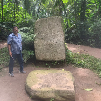
Monuments/sculptures | More than 200 stone monuments, including stelae, altars, animal sculptures, etc. Agencia Guatemalteca de Noticias+2Wikipédia+2 |
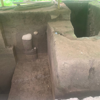
Channels / drainage | Ancient hydraulic systems, well-identified canals and drains, and architecture to control water, indicating a degree of urban planning. Asociación Tikal+1 |
👥 Estimated population during the boom
There is no precise archaeological data that says, "Y people lived in year X." But based on the site's size, the number of structures, monuments, and urban planning, archaeologists have made estimates or inferences:
It was a city of prolonged occupation: inhabited for approximately 1,700 years. With Criterion+2Wikipedia+2
Population density must have been highest during its peak periods, especially during the Middle-Late Preclassic (≈800–300 BC to 200–100 AD) when the city was flourishing as a commercial and cultural center with Olmec influences, and later during its early Maya phases. Wikipedia+2Tikal Association+2
Some estimates for comparable sites suggest that similarly sized cities in Mesoamerica may have housed several thousand people, perhaps 5,000–10,000 inhabitants (or more) at their peak. However, this figure for Takʼalik Abʼaj has not been confirmed by sufficient domestic remains or direct archaeological demographic data.
🔍 Relevant data (adding maps and population)
Here are some important details:
Tak'alik Ab'aj was not only a ceremonial center, but also an urban/commercial center, suggesting a stable resident population beyond priests or elites. Lab Academy + 3 Wikipedia + 3 Tikal Association + 3
Its strategic location near trade routes between the South Coast, the highlands, and other cities in western Guatemala favored its growth and ability to sustain a significant population. Wikipedia + 1
The large monuments, sculpted monuments, plazas, ball courts, and hydraulic systems point to a social organization complex enough to maintain community infrastructure, which also requires a sufficient population for collective work.
Cultural fusion: It is one of the most important sites demonstrating the transition between the Olmec and Mayan cultures. The sculptures feature Olmec styles and also elements that the Mayans would later use with greater development. (Authentic Guatemala)
Monuments and Sculptures: There are more than 200 sculpted stone monuments, stelae, and altars. (Prensa Libre)
Terraces and Architectural Groups: Tak'alik Ab'aj is organized into terraces—about ten successive terraces on the hillside—and four large groups of buildings: North, Central, West, and South. (Prensa Libre)
Economy and Trade: It was an important center of exchange. Products such as cacao, jade, obsidian, and salt were traded. It was also connected to other Mesoamerican regions. (Authentic Guatemala)
Ancient Royal Tomb: What is considered one of the oldest royal tombs linked to rulers of the Maya/Olmec region was found at Tak'alik Ab'aj, with offerings such as jade necklaces and female figures known as "The Offering of the Dolls." (Authentic Guatemala)
Abandonment and causes: A decline began in the Early Classic period, and by the Postclassic period, the city was largely abandoned. Factors such as the loss of trade routes and political pressures are believed to have contributed. (Prensa Libre)
🕰 Chronology and Preclassic Period
Takʼalik Abʼaj has a long period of occupation:
Phase | Approximate Dates | Main Features |
Early Preclassic | around 800-1000 BC to around 300-400 BC | Strong Olmec influence, early sculpture, development of ceramics, first monumental buildings. (Authentic Guatemala) |
Middle Preclassic | approximately 600-300 BC | Urban consolidation, blending Olmec and emerging Mayan styles, growing importance in regional trade. (Authentic Guatemala) |
Late Preclassic | c. 300 BC – 250 AD | Greater Mayan presence, early Mayan art, emerging hieroglyphic writing, more complex structures. (Prensa Libre) |
Early Classic / Decline | After 250 AD until approximately 900 AD | Phase of final splendor, many of the most elaborate sculptures and monuments, then decline, progressive abandonment. (Prensa Libre) |
🏛 What can be seen today
Partially restored structures: plazas, stairways, terraces. (TouristLink)
Many sculptures displayed outdoors: altars, stelae, heads, reliefs. (PBase)
Ancient drainage channels, urban planning elements, spatial organization that reflect a design based on cosmological principles. (Prensa Libre)
🌄Contemporary Importance
Archaeological site and national park with tourism services. (PBase)
Recently declared a World Heritage Site by UNESCO, reinforcing its universal value. (UDG TV)
A source of cultural pride for Guatemala and an educational/scientific resource for archaeology, anthropology, and history.


Comments